


Geographic Profile
Population: 1.27 billion as on January 2014
Capital: New Delhi
Major Cities: Mumbai, Kolkata, Bengaluru and Chennai
Area: 1,269,219 square miles (3,287,263 sq km)
Bordering Countries: Bangladesh, Bhutan, Myanmar, China, Nepal and Pakistan
Coastline: 4,350 miles (7,000 km)
Highest Point: Kanchenjunga at 28,208 feet (8,598 m)
Introduction
The Republic of India, area-wise, is the 7th largest country and is 2nd in terms of population, in the world. India covers an area of 32,87,2631 sq.km., lying fully in the northern half of the hemisphere. North to South India runs through a length of 3,241 km and East to West 2,933 km. The international boundary runs throughout the frontier for a length of 15,200 km.
The co-ordinates of the country are 8º4′ and 37º6′ north of the Equator with Bay of Bengal situated in the east, the Arabian Sea towards the west, and the Indian Ocean to the south. In the western part lies the Lakshwadeep group of islands and on the eastern the Andaman and Nicobar archipelago. The Indian coastline runs for the length of 7,516.5 km.
Physical Features
Himalayan Mountain – The largest mountain range in the world, the Himalayan Range hosts some of the most prominent peaks in the world such as
- Everest (8848m),
- Kanchenjunga (8598m),
- Nanga Parbat (8126m),
- Nanda devi (7817m), and
- Namcha parbat (7756m).
The Himalaya Mountain range runs along for a length of about 2400 km. from north-west to south-east direction.
The Indus-Ganga-Brahmaputra Plain – The plain spreads out for about 3,200 km. in the adjacent area between Ganga and Indus. The width of the plain varies from 150 to 300 km. The plain is essentially alluvial in nature.
Peninsular plateau – The Peninsular plateau extends from the Delhi ridge to the Rajmahal hills and terminates at the apex formed by the Kanya Kumari region. The Peninsular region is surrounded on the apex and adjacent sides by the Bay of Bengal, Arabian Sea and Indian Ocean.
Western ghats – The ghats stretch uninterruptedly from the southern tip of the peninsula to the Deccan and Karnataka plateaues. The ghats are dominated by granite and gnesis varieties of rocks and vary in altitudes from 900 to 1600 meters.
Eastern Ghats – The Eastern ghats are essentially an intermittent range of hills i.e. Nallamalais, Pachaimalais, Palkondas and Velikondas.
The Coastal Plains and the Islands – The Western coastal plains are dominated by Gujarat and are alluvial in nature, which are interspersed by hilly terrain. On the other hand, the Eastern coast has wide spreading plains with a highly developed deltaic pattern crisscrossed by numerous rivers.
River System of India
The Himalayan Rivers – Snow-fed and perennial during the monsoon months, heavy volume of water flows through this system.
The Deccan Rivers – Fully dependent on rain and therefore are non-perennial in nature.
The Coastal Rivers – Short and limited in scope and are therefore non-perennial in nature.
The Rivers of the Inland Drainage Basin – Flows and either drains in salt-lakes or are lost in sands.
Others Geographical Facts
Climate – The Himalayan mountain range acts as a major determinant of the climate. The monsoon characteristics are evident throughout the country, in spite of variations in climate patterns owing to diverse relief. Rainfall is most intense in the north-eastern region and the western slopes of the Western Ghats. Varied amount of rainfall is available for the rest of the country, in accordance with the topography in and around the region.
Natural Vegetation – The Himalayan region is dense with the flora and fauna, akin to the Tundra variety. Though the amount of rainfall determines the vegetative characteristics the altitude also plays as a major determinant. Tropical-deciduous and evergreen verities dominate the vegetation. Mangrove and swampy vegetation is evident in some parts of the deltaic region of the Sunderbans.
Population – The 2nd most populous country in the world, the population stands at almost 1.27 billion as on January 2014.
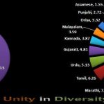
Languages – Officially 22 languages are recognized but census reveals almost 1,652 dialects; Hindi, Bengali and Marathi being the most spoken languages.
Natural resources – Coal, Iron ore, Mica, Manganese, Titanium ore, Diamonds, Natural gas, Bauxite, Chromite, Petroleum, Limestone, Arable land.
Economy
Being a mixed economy, agriculture plays a significant role from the perspective of the Indian economy. The Service sector is also progressing to be a major determinant. The primary and prevalent industries are textiles, iron and steel, petroleum, food processing etc. On the agricultural front, rice, wheat, tea, cotton, oilseed, sugarcane, dairy products, livestock are significant.
Related posts:
 DEMOGRAPHICS OF INDIA
 Flora and Fauna
 Great Indians
 Indian Sports
 National Animal Tiger
 National Anthem of India
 National Bird of India – Peacock
 National Emblem
 Independence Day 2022 – National Flag of India – Tiranga (Tricolor)
 National Flower of India – Lotus
 Nature – Amphibians
 Nature – Animals
 Nature – Birds
 The Indian Government
 Blood Donation
 Adoption Of Child