


Rivers of India
Among the most distinctive features of India is their river, which holds the highly religious importance among its people. Covering the vast geographical area of 329 million heactares, Indian rivers have been an important reason for the rural prosperity of India. Carrying a wider importance in cultural, economical, geographical as well as religious development, the numerous river of India is of great value in India. The rivers in India are considered as God and Goddess and are even worshiped among the Hindus. They provide tourists a wonderful insight into the historical, cultural and traditional aspect of India. Some of the most prominent rivers in India include Ganga, Yamuna, Krishna, Godavari, Narmada and Kaveri.
Ganga (Ganges)
The Ganges has been a symbol of India’s age-long culture and civilization, ever changing, ever flowing, and yet ever the same Ganga. Jawaharlal Nehru, First Prime Minister of India, born in Allahabad on the Ganges. The river known as the Ganges is officially and popularly known by its Hindu name, Ganga. The river Ganges is very sacred to the Hindus. The river has its source in the Himalayas, at Gaumakh in the southern Himalayas on the Indian side of the Tibetan border. It is 1 560 miles (2 510 km) long and flows through China, India, Nepal and Bangladesh. The Ganges river basin is one of the most fertile and densely populated in the world and covers an area of 400 000 sq miles (1 000 000 sq km). The river flows through 29 cities with population over 100,000, 23 cities with population between 50,000 and 100,000, and about 48 towns.
Ganga is the sacred river of India. Ganga originated from the Gangotri Glacier, which is located in the western Himalayas.
History
The history of the Ganga river is old as the Indian civilization. For the years Ganga has been the only spectator of all changes that have shaped the Indian history, culture and its people. It has seen the rise and fall of many empires. It has been the prime witness of all the religions especially Hinduism, Buddhism, Islam, Christianity and Jainism.
There are many stories as to how river Ganga came down from haven to earth. According to the Indian ancient books, King Sagar had sixty thousand sons who were burnt to ashes due to the anger of saint Kapil Muni. They blamed that the saint has stolen a horse of the ritual yagna of King Sagar. King Sagar took suggestion from various saints regarding the salvations of his sons. They all suggested that if the Holy Ganga is brought from the haven and the ashes of his sons were dipped in it, their souls will definitely achieve nirvana or moksha. King Sagar requested his son Bhagirath to worship Lord Brahma. He does the same for many years. When Brahmaji was pleased, he asked him to release Ganga from his Kamandal and let it flow on the earth. Brahma told that he would do as such but the earth will not be able to tolerate the extreme velocity of Ganga. That is the reason Lord Shiva received Ganga on his head. Lord Shiva did so but somehow Ganga got stuck in his hair. King again worshiped Shiva to release Ganga from his hair. Since then Ganga has been flowing on earth and is worshiped by billions.
Religious Significance
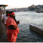
Ganga is regarded as the holy river of India. According to the Hindu beliefs a dip in the Ganga water can wash away all the sins. Thousands of people spend the last days of their life on the bank of the river. Ganga is regarded as the Goddess and is worshiped among the Hindus. Ganga Devi is one of the two daughters of Meru (the Himalayas), the other one is Uma (the consort of Shiva). Every day the arti (prayer) is done on the bank of the river to pay homage to the Goddess Ganga. Many people in India call Ganga as Ganga Ma. Ganga finds mention in the ancient Hindu scriptures called Rig Veda.
Pious Cities Enroute The Ganges Journey
Varanasi
The virtuous Varanasi on the banks of Ganges is one of the most important pilgrimages for Hindus and Buddhists. At Varanasi the Ganges river flows from south to north, ie. back towards its origin in the Himalayas, considered a most auspicious phenomenon by Hindus. Varanasi has been the center of education, religion, art of culture since ages. Varanasi indeed offers the incredible India at its religious and cultural zenith.
Haridwar
Haridwar is considered as one of the seven holiest places according to Hindu mythology. According to the legends, when the Gods left their footprints on the land of Haridwar. Its geographical location stands as the gateway to the four pilgrimages of Uttrakhand.
Cleaning The Ganges
Along with the glory of Ganga, comes the pollution as well. The pious river has become an agent of the worst waterborn diseases like dysentery, hepatits, and cholera. Money is being raised by the government and other groups such as the Swatcha Ganga to clean the Ganges. The Ganga Action Plan was also initiated with the objective of purifying the holy river. None the less, the Ganges is still the purifying waters for the Hindus of India.
Economy
Ganga has been serving million people for the centuries. Its fertile soil is good for the agricultural purpose. It serves as the source of irrigation to the large area. Some of the crops that can be cultivated along the river include rice, sesame, sugarcane, millets, wheat, potatoes, sugarcane, jute and seeds. Ganga has been the source of drinking, bathing and baptism.
Adventure
Ganges has been the ultimate rafting site in India. The magic of white water rafting at the Ganges especially in Rishikesh is beyond one’s imagination. Besides rafting you can also try out various other water sports in its water. Apart from the water sports Ganga holds the great wildlife. It is the home to number of resident and migratory birds.
Yamuna
Origin of Yamuna River
The holy river Yamuna originates from the Bundar Poonch glaciers located in the state of Uttaranchal in India. It begins its journey from Jamunotri in the north of the Himalayan ranges. The total length of the river Yamuna exceeds up to 1,370 kms.
History
According to the ancient Indian scriptures Yamuna was the daughter of the Sun God called Surya, sister of Yama (the God of death). River Yamuna is deeply connected with the Lord Krishna’s birth. After his birth his father Vashudeva crossed the River Yamuna carrying him in the bucket. When Lord Krishna fell into the water, Yamuna once again became sanctified with the dust of his lotus feet. There are lot more stories connected with the River Yamuna in India.
Holy Bath
According to the legends, by taking a dip in its water one can be freed from all the past sins of his life, as it is the same place where Lord Krishna used to play during his childhood. There is popular belief among the Hindus in India, according to which one who take bath in its water do not fear death.
Religious Importance
Yamuna also known as Jamuna in India is regarded as Goddess in India. Many people in India call it Jamuna Mata and worship it. There are many festivals celebrated on the Yamuna River. Some sat that the source of the river Yamuna is the glacier lake called the Saptarishi Kund. There is also a sacred shrine of Yamunotri near this source. Every year thousands of pilgrims gather at te temple dedicated to the Goddess Yamuna. Yamuna River finds mention in the great Indian epic Mahabharata and Ramayana.
Journey of River Yamuna
River Yamuna flows in the state of Uttar Pradesh and other parts of the northern India. It rises from the Himalayas near Yamunotri and from here the river flows through the Mathura Virandavan. Then she moves towards the southern parts of India and passes through the southeastern parts. At one point she reaches Prayag, where she joins the Holy Ganga. After that both Ganga and Yamuna flows till Ksheer Sagar.
Flora and Fauna
The river holds the rich flora and fauna around itself. It is home to number of wild animals especially the Indian elephants.
Dump Ground For Pollution
Today however, this majestic river is polluted with domestic waste, silt, and industrial waste. The 22-km stretch between Wazirabad and the Okhla barrage in Delhi is only 2% of the catchment area, but it contributes about 80% of the river’s total pollution load. The Hindon Canal also discharges waste from Uttar Pradesh in this stretch. Among the many casualties are birds and fish. There was a time when bird watchers had identified as many as 30 species of birds near the Yamuna, many of them exotic, such as the red-crested pochard and the godwit.
Yamuna Action Plan (Yap)
In recent years the river has become grossly polluted due to various causes affecting human health and bio-diversity of the eco-system. One of the main causes of pollution of the river is discharge of untreated domestic wastewater and other wastes into the river from the towns located along its banks. To arrest river pollution, certain measures of cleaning river have been taken by the Ministry of Environment and Forests, of the Government of India.
Godavari
There are seven main/ sacred rivers in India – Ganga, Yamuna, Sindhu, Saraswati, Godavari, Narmada and Kaveri. All of them have their own significance. But there is one thing which is common to all – they all come from the melted Ice of Himalayas.
In a Religious Country like India, the water of Rivers is not only used for irrigation purposes, but they are also revered as Goddesses. They are often prayed, fasts are kept to keep them happy and temples are built in their respect. There are also a number of festivals held in their respect. Various religious and cultural festivals are held on the banks of rivers and people feel blessed by taking a dip in the holy waters of these rivers.
Origin of River Godavari
The Godavari river rises near the Trimbak in the district of Nasik in the Indian state of Maharashtra. The river is approximately 1,465 km long and has a total catchment area of 31 mha. It flows in the eastward direction through the states of Maharashtra and joins the Bay of Bengal in Andhra Pradesh. The principal tributaries of the River Godavari are Penganga, Pranahita, Sabari, Indravati, Manjeera and Manair. It is the second largest river in India.
Religious Significance
Apart from Ganga and Yamuna, Godavari also holds the special religious importance in India. Godavari is one of the sacred river in India. According to the puranas River Ganga should only be visited after the visit to the Godavari. There are several pilgrimage places on the banks of the river. Some of them include Trimbakeshwar – the ancient temple of Lord Shiva, Nanded Takht Sri Hazur Sahib, one of the sacred place among the Sikhs, Bhadrachalam – temple of Lord Rama and many more.
Godavari is sometimes also referred to as the ‘Ganga of the South’. After every twelve years, a major bathing festival called as Pushkaram is held on the banks of the Godavari river. Some of the prominent personalities who took bath in its holy water include Baladeva and Chaitanya Mahaprabhu.
Pollution
River Godavari is under the serious threat as a result of the growing Urbanization and industrialization. The river has been dying at an alarming rate due to the pollution created by the factories. The main reason behind the pollution of Godavari river is the tiny Nakavaggu rivulet, which joins the Manjira, tributary of the Godavari. Nakavaggu rivulet supports no life at all. Rivulet is surrounded by the highly productive agricultural land, which is polluted by the large number of industries lying near the twin cities of Secunderabad and Hyderabad. However the 72 industries in the Patancheru Industrial area dumping the chemicals and waste into the water are most responsible for the pollution of the river. It has also given rise to some of the major diseases such as lung cancer, leukemia, and liver cancer. The government of India has been continuously taking steps to save the river water from further pollution.
Kaveri
The Kaveri river is the smallest of the five major rivers of the Indian peninsula, the others being the Mahanadi, Godavari, Narmada, and Krishna. However, it forms perhaps the most important watershed of the South.Known as “Dakshin Ganga” (the Ganges of the South), it serves as a lifeline to the people of Southern Karnataka, and the Cauvery basin of Tamil Nadu.
Origin of the River Kaveri
River Kaveri originates in the Brahmagiri hills in Kodagu, in a place called Talakaveri (head of Kaveri). It starts its journey from the small pond called as Kundike pond, later the two tributaries known as Kanake and Sujyoti joins it. All these three rivers meets at the point called Bhagamandala. It lies at an altitude of 1350 meters and generally flows from the south to eastward direction. The river is approximately 760 km long. Its flows in the state of Karnataka and Tamil Nadu and merges into Bay of Bengal. The principle tributaries of the river Kaveri include Shimsha river, Hemavati river, Arkavathy river, Honnuhole river, Lakshmana Tirtha river Kabini river, Bhavani river, Lokapavani river and the Amaravati river.
Story of Popularity behind River Kaveri
There are many different stories behind the birth of River Kaveri. One of them goes as such- In the ancient times the condition of the south India was becoming worse due to the severe drought in the area. Watching this sage Agastya felt very sad and prayed to the Lord Brahma to help the mankind to come out of this situation. Brahma said if you go to the place where Lord Shiva lives and collect some of the snow water that never ends, than you will be able to start a new river. Rishi Agastya went to the mount Kailash and filled his pot with the snow water and went back. He started searching for the good place to start the river in the hilly Coorg region. He became tired searching for the right place and handed his pot to the small boy who was playing there. That little boy was actually Lord Ganesha who selected the place to start the river and slowly put the pot down and disappeared. After some time Agastya called out – Little boy what do you think. He got no answer. Soon he noticed a crow spilled the pot of snow water on to the ground. After some time Lord Ganesha appeared instead of crow with the smiling face. He said I have done nothing wrong but have helped you in finding the right place to start the river. Sage Agastya smiled and Ganesha disappeared. This is how rishi Agastya brought River Kaveri into the Himalayas.
Another Legend
There was a childless king named Kaverna and Brahma gifted him a beautiful girl Kaveri. She was married to Agastya muni on the condition that he would never leave her alone. One day, Agastya muni began teaching his disciples a difficult lesson in philosophy. Assuming that something unfortunate had happened to him and not wanting to live alone she jumped into a tank. But she did not die. She became a river, flowed up the Brahmagiri Mountain and reappeared as a spring.
Religious Importance
The River Kaveri is the sacred river of India and holds the special religious importance. People in India considers river Kaveri as Goddess and worship it. She has been referred o as the Goddess Kaveri Amman. According to the legends she purifies our karmas and washes away all our sufferings. She is the Universal mother and is believed to give us peace.
The Journey
The River Kaveri flows through the states of Karnataka and Tamil Nadu. Its source is a spring in the Brahmagiri Mountains in Mysore at a height of 1320 metres above sea level. The Kaveri is not the same throughput its length of 765 kilometres. As the Kaveri flows down the Brahmagiri mountain and enters the plain, two small rivers, the Kanaka and the Gajoti, join it.They meey at the town of Bahamandalam till here it is a small river. two more rivers, Hemavati and Lakshman Theertham join it, that it becomes a large river, broad and deep. It is here that the water of the three rivers is collected in the Krishnaraj Sagar reservoir, on the banks of which is laid one of the most beautiful gardens of Mysore – Brindavan.
In Spotlight- ‘Flood of the Eighteenth’
This river runs through some of the richest south Indian lands, watering the fields and blessing the people on its course. The people of Tamil Nadu celebrate the flood in the in a special way with a festival. This festival is called the ‘Flood of the Eighteenth’. On the eighteenth day of the month of Aadi (July-August), people come to worship the river. They light special lamps and express their gratitude by throwing offerings of fruits, sweetmeats and flowers. It is a day of rejoicing for the people as they thank the river goddess for her blessings and prosperity.
Krishna
Krishnaveni or River Krishna meaning dark in Sanskrit, is one of the largest and longest Rivers of India. Originating in the Western Ghats at an altitude of 1300 ft above the sea level in Mahabaleshwar it ends at Bay of Bengal & three states Maharashtra, Karnataka and Andhra Pradesh it covers an approximate area of 1300 kms. In India, the river waters are transparent, light, stimulating, light , appetizing and sweet. They are dranked, prayed, poured and used for various purposes. However the properties of river waters differ according to the areas in which they flow. The waters of the rivers nearing the sands and stone are pure; those coming from Himalayas are sweet as nectar; those flowing east from the Vindhyas are supposed to produce rheumatism, those flowing towards are supposed to cure phlegm; those flowing though north cure digestive problems and those flowing towards west tend to excite bile.
Religious Significance
River Krishna is sacred among the Hindus in India. The river is named on the name of the Lord Krishna. It is believed that by taking the ritual dip in its water can purify all the past sins of the human beings. The river is referred to as the Krishnaveni mata among the Hindus. There are many pilgrimage centers on the banks of the River Krishna including Mallikarjuna temple (Srisailam), Amareshwara Swamy temple (Amaravati), Dattadeva temple, Sangameshwara Shiva temple, Ramling temple and Durga Malleshwara temple (Vijyawada). The center of attraction is the Krishna Pushkaram fair which is held one in twelve years on the banks of the Krishna river.
Flora and Fauna
The wide spread area near to the Krishna river holds the rich flora and fauna. The last surviving Mangrove forests in the Krishna estuary have been declared as the Krishna Wildlife Sanctuary. The sanctuary is the home to the large number of resident and migratory birds. Fishing cat, otter, Estuarine crocodile, spotted deer, sambar, black buck, snake, lizards and jackal can also be spotted in the sanctuary. The sanctuary also supports rich vegetation with plants like Rhizophora, Avicennia, and Aegiceros.
Pollution
River Krishna is dying at an increasing rate. The river receives the waste from the large number of cities including Hyderabad, Pune, Satara, Kolhapur, Kurnool and many more. The sewages from the twin cities of Hyderabad and Secunderabad flows into it. Large number of industrial units operates from the river basin which are the main reason for the water pollution in the Krishna river.
Dams on the Krishna
Two dams have been constructed on the Krishna River, one at Srisailam called Srisailam dam and other one at the Nagarjuna hill. There are many waterfalls found along its tributaries namely Ethipothal a, Pedda Dukudu, Gundam and Chaleswaram.
Narmada
Narmada undoubtedly is India’s most breathtakingly beautiful river. She is also the most feminine in her movements, as she slithers through thousands of kilometers of hostile terrain.
Origin of the Narmada River
Amarkantak is the place from where the Narmada River originates. It raises from the Maikal ranges at the height of 1057 meter above the sea level. Amarkantak is located in the Shahdol district of Madhya Pradesh in India. Narmada River mainly flows in the central India. The total length of the Narmada River lays approximately 1,289 kms. The river flows from the eastward direction to the westward into the Arabian Sea. It merges into the ocean at the point called ‘Bharonch’. It is the largest west flowing river in India.
Religious Significance
Narmada is one of the sacred rivers of India. It is said that by taking a bath in the holy Narmada River, man can be freed from all the sins of his life. The water of Narmada River purifies a man and helps him in attaining salvation. Among the people in India, Narmada River is considered as the mother and the giver of peace. The Narmada finds mention in ancient texts of India as one of the seven most sacred rivers in India. The river is considered as the Goddess and is worshiped in India. There are numerous thirthas on the banks of the river; the most important among them are Mahewswar and Omkareshwar tempes.
History
According to the legends, Narmada river came down from the sky as by the order of the Lord Shiva. Some also says that the Narmada river also sprangs from the body of the Lord Shiva, while performing the tandava (Lord Shiva’s cosmic dance). Narmada means ‘Giving Pleasure’. In Sanskrit Narma means ‘pleasure’ and da refers to ‘to give’. In some parts of India Narmada is also known as Narbada.
The Narmada Valley Project
After the commencement of the five year plan there has been demand to fully utilize the water of Narmada. As the Narmada flows through the states of Madhya Pradesh, Gujrat and Maharashtra has led to the dispute among these concerned states. In order to solve the problem, the Government of India constituted the Narmada Water Dispute Tribunal. The plan was meet the water requirement of the people and industries as well as the regular supply to them. Large population of India including the tribal population such as Gonds, Bhils, Santhals, Kurkus are heavily dependent on its water. According to the current plans, Narmada basin has 3200 dams. Out of these 30 are the major dams, 135 are the medium one and rest are small. The plan is to provide substantial amount of electricity and provide water for irrigation of millions of acres of crop land.
Along the river
The Narmada River has also supported large variety of people with distinguish culture and traditions ranging from indigenous tribal people inhabitation in the forest areas to the rural population. The banks of the Narmada River are dotted with many temples. On the starting point of the Narmada River lies a open pond known as the Narmadakund. The pond is surrounded by many temples such as Shiva temple, Shri Ram Janki temple, Annapurna temple, Durga temple, Vangeshwar Mahadev temple, Shiv Pariwar, Sri Radha Krishna temple, Guru Gorakhnath temple, Kartikey temple and many more. The river supports the great variety of aquatic life, which includes marsh crocodile and masher fish. Apart from that large number of wild animals and their natural habitats can also be spotted here such as tiger, gaur, sloth buck, black bear, boar, wild dog and many more.
Tapi / Tapti River
Tapti River/ Tapi River are a river of Central India. Tapati, Tapti, Tapee, Taapi are the various names used to denote Tapti River. Also known as the daughter of Sun God.
Origin of Tapi River
Tapi river is one of the major rivers in India. The total length of the Tapi river is approximately around 724 km. It flows in the central part of India. The river originates from the Betul district of Madhya Pradesh in the Satpura range at an elevation of 752 meter above the sea level. The states through which the Tapi river flows include Maharashtra, Gujrat and Madhya Pradesh. Apart from the Narmada river, Tapi is the only river which flows in the westward direction and merges into the Arabian Sea. The Tapi basin extends to the total area of 65, 145 sq km, which is approximately 2.0% of the total geographical area of India. The main tributaries of the Tapi river are Purna, The Girna, The Panjhra, The Vaghur, the Bori and the Aner.
History of Tapi River
In the earlier times Tapi river at Surat was used as the major ports for the purpose of exports of goods and also as an important stopover destination for Muslim pilgrimage called Haj to Mecca.
Other Names of the Tapi River
Tapati, Tapti, Tapee, Taapi are the other names used for the Tapi river in India.
Religious Significance
According to the legends, Tapi river also known as Tapti is the daughter of Surya (the Sun God). Some says that Surya created the Tapi river in order to save himself from his own intense heat. The river finds mention in the great Indian epic Mahabharata, according to which Tapti had married Sanvaran, a legendary hero of the moon dynasty. Tapti and Sanvaran also had the son called Kuru. It was on his name only the Kuru dynasty started. Tapi is considered as the Goddess among the Hindus and is worshiped among them.
Around Tapi River
Tapi river is been supporting the large number of population especially the indigenous people such as Dhodia, and Bhils who are heavily dependent on it. The soil around the Tapi river is good for agriculture. The rural and tribal population around the Tapi river grow large number of chief crops around it and sell it in the market to earn their livelihood. The water of the Tapi river is widely used for the irrigation purpose. Tapi river is the home to the natural habitats of many wild animals including tigers, sloth bear, lions, snakes and many more.
Bhramputra
Brahmaputra is the biggest of the Indian rivers, even bigger than the Ganga. Brahmaputra is regarded as one of the great rivers of southern Asia (1,800 mi) long. In Sanskrit, it means “son of Brahma”.
The Journey
The Brahmaputra River flows 2,900 km from its source in the Kailas range of the Himalayas to its massive delta and the Bay of Bengal in Bangladesh. It flows through China, India, and Bangladesh, but its watershed includes Nepal, Bhutan, and Burma as well. The river drops steeply from high on the Tibetan Plateau through the world’s deepest valley (5,075m) into northeast India where the river eventually merges with the Ganges and Meghna rivers to form the largest river delta in the world (60,000km2). The plains watered by the stream yield abundant crops of rice, jute, and mustard.
Legend Behind Brahmaputra
In the ancient Indian tradition, two rivers are known to originate from Manasarovar Lake, in Mt. Kailas; one flowing to the east is called Brahmaputra and the other flowing to the west was called Shatadru, a tributary of the Sarasvati (joining the latter at Shatrana, Punjab) in Rigvedic times. Both these major rivers, Brahmaputra and Sarasvati are related to the God of creation, Brahma. The lower portion of the river is sacred to Hindus.
Overview
The river’s three names, the Brahmaputra (India), Yarlung Zangbo (Tibet), and Jamuna (Bangladesh), reflect the social fabric of ethnic groups and international communities living along its banks. The river is considered to be a symbol of synthesis of people of all religions, castes and creeds.
The river Brahmaputra drains a vast area of nearly 9,36,800 sq. kms. It is a river of immense importance and navigable from the Bay of Bengal to Assam, a distance of nearly 1,280 kms. It is a splendid waterway for commerce and travel.
The Course
After entering the hills of Assam Brahmaputra flows to Guwahati. Here lies a very ancient place of pilgrimage, the temple of goddess Kamakhya on a hill. The river then passes through Umananda Bhairab, with its granite foundations rising from the lap of the river. The river then reaches Pandughat, close to which lies the hill station of Shillong. The river flows through various towns til it reaches Goalundo. It is here that the river Ganga joins it to form the river Padma. The river then flows towards Calcutta and then finally empties itself in the Bay of Bengal.
Sangam
Sangam is the confluence of three of the holiest rivers in Hindu mythology – Ganga, Yamuna and the mythical Saraswati. At the Sangam, the waters of the Ganges and the Yamuna can be distinctly seen to merge into one. At Allahabad, the meeting point of the rivers is believed to have great soul cleansing powers and is a major pilgrimage site. It is even more holy because the invisible Saraswati river is supposed to the join the Ganga and Yamuna at this point.
Legendry Saga
According to traditions, the gods and demons once churned the oceans to retrieve a pitcher containing the nectar of immortality – amrit — after which a struggle ensued between the two to wrest control of this pitcher. It is said that during the scuffle, a few drops of amrit were spilled at places, making them hallowed and sacred. The waters at the Sangam are believed to have received the amrit too and a dip in these holy waters during the Kumbh is believed to cleanse and purify the soul.
Religious Importance
Brahma is said to have called this spot Tirth Raj, or ‘King of Pilgrimage sites’. The holy confluence draws pilgrims at all times, especially during the Kumbh Mela time when loyal pilgrims gather here to offer their penances and seek blessings.
It is believed that it is at the Sangam, that a few drops of the nectar ‘Amrit Bindu’ fell making its waters truly spiritual and replete with soul-cleansing powers.
Festival Highlight
During the month of Magha (Mid Jan to Mid Feb) hundreds of thousands of pilgrims come to the bath at this holy confluence for the festival known as Magh Mela.
The most propitious time of all happens every 12 years when the massive Kumbh Mela takes place. At this time the Sangam truly comes alive and attracts the devout/tourists from all over the world. Millions of devotees bathe ritually in the waters to break the eternal cycle of reincarnation.
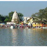
Mahanadi
Mahananadi River is the river which is the life line of Chattisgarh. It flows from the Eastern Ghats to the Bay of Bengal through Cuttack, in the eastern Orissa State. Rising from the highlands of Chattisgarh, it flows through Orissa to reach The Bay Of Bengal.
Like all other rivers, the Mahanadi too is revered one. It plays a major role in people’s life and is part of all the major religious functions and festivals. The water of Mahananadi is considered to be auspicious for any occasion – be it good or bad. It is thought that the water of Mahananadi has the power of converting bad into good.
Satluj
Also known as the Red River, Satluj /Satlej River is the longest river amongst the five rivers flowing through the cross river of Pakistan and Northern India. Satluj is one of the three Trans Himalayan Rivers originating in the high Tibetan Plateau which cuts across the Himalayan Ranges. Satluj crosses the three main mountain ranges – the Zanzkar Range, the Great Himalayan Range and the Dauladhar Range. However the source of Satluj River in India is the Mansarovar Lake at 18500ft in Tibetan Range.
Sindu
In Sanskrit, the river Sindhu means Ocean. This river goes back to the Age when Jayadratha, son of Vriddhakshatra was the ruler of the Sindu Kingdom. It was the time of famous Hindu Epic Mahabharata. And from here, the lands of Sindh came the name of the River Sindhu. Indus Valley Civilization came into existence only after the river Sindhu paved way for them.
Of the seven most holy rivers in India the Sindhu is significant in that it is from the Sindhu that India has got her name [Sindhu-Indus-Indica-India] The Rig-veda refers to the Sindhu River as very auspicious and it is from the name ‘Sindhu’ that the word ‘Hindu’ also comes. Due to a speech variation the Persians referred to those people east of the Sindhu River as Hindus.
After the time of Alexander the Great [circa 350 BCE] the Sindhu became known as the Indus River and the lands to the east of the Indus were known as Indica. During the British Raj, Indica came into the English language as India. Thus; the name India. But as we know the Vedic name of India is Bharata and it is still in vogue today among the learned.
My recent trip to Ladakh gave me the opportunity to have a darshan of the Sindhu River — something i had looked forward to for many years. The Sindhu originates from Mount Kailash deep in the Himalayan range and flows westward across modern day Ladakh and Kashmir where he [a masculine river] then enters Pakistan and then flows south to eventually reach the Arabian Sea.
Many Hindus come to Ladakh every year to have darshan of the Sindhu and a great Darshan Festival is held in June that is attended by thousands. Myself, Kunjabihari and Rupanuga however preferred to go for darshan at a time with less crowds, the end of September. It was a wonderful experience. Here are a few photos of the Sindhu River and also the sangam where the Zanskar River joins the Sindhu.
Jehlum
One of the few rivers that have their origin in Kashmir itself, Jhelum River is a beauty in itself. The river originates in Vernag, shooting out from a spring. Vernag is located at lower Pir Pinjal in Kashmir Valley. The River Jhelum starts from Kashmir, flows through a long stretch of Jammu before finally surrendering itself to the Indus River.
Since the Jhelum River crosses both the regions of the state, it enjoys an immense importance among the various Rivers & Lakes of Jammu and Kashmir. Not only Jammu and Kashmir, the river flows through the state of Punjab and enters Pakistan also.
Over the years the Jhelum River has emerged as a major tourism attraction. The Mangla Dam built on the river is one of the largest earth-fill dams and a great tourist destination. The Jhelum River bifurcates the beautiful Srinagar city into two parts. The wonderful lakes of the city are mostly fed by water from Jhelum.
The River Jhelum in its path takes the form of a stream and act as lovely camping sites for campers and trekkers. The nine bridges over the river Jhelum, which were built long ago, also serve as hot tourism sites. You must visit these places to feel the real essence of the areas.
Chenab
One of the most important Indian rivers, the Chenab River is formed as the result of conflux of the rivers – Chandra and Bhaga. The rivers meet at Tandi in the lap of Upper Himalayas. The Chenab River also called as the Chandrabhaga in its initial stages.
Although it commences its journey from Himachal Pradesh, it has become on of the major Rivers & Lakes of Jammu and Kashmir. It also enters the state of Punjab. The Chenab River meets several other rivers at different places. These rivers are: –
- Jhelum
- Ravi
- Sutlej
- Beas
The Chenab River of Jammu – Kashmir not only has geographical importance but has a great historical value attached to it. It was known as the Ashkini in the Vedic Age. It was also known as the Iskamati. The invading Greeks led by Alexander the Great referred it as the River Acesines.
Some of the greatest mythological stories and epics have mentions of the ancient Ravi River. The river plays an important part in Heer Ranjha and Sohni Mahiwal – two of the eternal Indian love stories.
After leaving the Kulu and Kangra Districts of Himachal behind, the Chenab River enters the state of Jammu and Kashmir at Tandi at an altitude of 9,090 feet. The river gains momentum on the way with contributions from numerous branches.
Ravi
Lying on both the countries – India and Pakistan, the Ravi River originates in the Himalayas in the Chamba District of the state of Himachal Pradesh. With the presence of heavenly beauty along its banks, nature lovers consider itself as one of the most romantic rivers of the country. The flow of the River Ravi can be compared with a romantic poetry.
Among the many Rivers & Lakes of Jammu and Kashmir, the River Ravi will always hold a special position by its beauty and geographical value. The river starts its Journey from Himachal Pradesh and crosses Punjab, Jammu & Kashmir before entering Pakistan. The great city of Lahore in Pakistan is built along the riverside of Ravi.
The Ravi River has a total length of around seven hundred and twenty Kilometers and joins the Chenub River in Punjab. The elegance of the Ravi River in Jammu Kashmir has contributed to the picturesque landscapes of the state. The river is one of the many tourism destinations of the state. Various activities like white water rafting, water skiing, fishing, riverside camping etc. are practiced in the River Ravi.
Beas
The Beas forms the valleys of Kullu and Kangra, famed for their beauty. But ironically, its source is an insignificant looking igloo like structure near Rohtang Pass in Pir Panjal range to the north of Kullu. The main thrust of this river is southward to Larji and then to the west. Where it enters Mandi district and further still into Kangra. On account of its snow-fed, perennial tributaries, its inflow increases greatly during the monsoons, sometimes resulting in floods. At the Pandoh, in Mandi district, the waters of the Beas have been diverted to the Sutlej through 53-km of tunnel, with the Pong Dam constructed on the Beas, for the purpose of increasing the hydroelectric power supply.
Saraswati River
The Ghaggar-Hakra River, also known as the Saraswati River, is a trans-boundary river in India and Pakistan. The river runs in both the nations only in the monsoon season. Prior to the Ottu barrage, the name of the river is Ghaggar and after it crosses the barrage, it is named as the Hakra downstream. The Saraswati or Ghaggar-Hakra River is normally denoted as the Sarasvati River in the Vedas by majority of researchers. Nevertheless, there is a debate that whether all quotations to the Sarasvati in the Rig Vedas should be utilized to denote this river. Scholars like Jane Macintosh, C.F. Oldham, Marc Aurel Stein, Max Müller, and Christian Lassen have acknowledged the recognition of the Vedic Sarasvati River with the Ghaggar-Hakra River.
The Saraswati River: An Overview
The Ghaggar River
The Ghaggar is a trans-boundary river in India, running during the monsoon season. The source of the river is located in the Shivalik Mountains of Himachal Pradesh. The river runs through Punjab and Haryana states and penetrates Rajasthan; merely southwest of Sirsa in Haryana and alongside Talwara Jheel in Rajasthan. This recurrent river supplies two irrigation channels that stretch into Rajasthan.
The contemporary Sarsuti (Saraswati River) has its source at the foothills of a mountainous area in the Ambala district (Haryana) and meets the Ghaggar close to Shatrana in Punjab. A dehydrated waterway of the Sutlej meets the Ghaggar close to Sadulgarh (Hanumangarh) and the name of the conduit is the Naiwal canal. The Ghaggar is subsequently joined by the desiccated Chautang (Drishadvati) river in the vicinity of Suratgarh.
The broad paleochannel or riverbed of the Ghaggar River implies that at one time, the river was running with full strength during the famous liquefaction of the Ice Age glaciers in the Himalayan Mountain Ranges about 10,000 years back, and it subsequently went on across the whole area, in the currently waterless canal of the Hakra River, probably pouring into the Rann of Kutch.
The river apparently got dehydrated because of the detention of the tributaries by the Yamuna River and Indus River System, and afterward, moreover, the desiccation in most of its drainage basin because of cutting down of trees and overgrazing. Some researchers thought this to have taken place at the most recent in 1900 BCE, however it originally happened much before.
Verma and Puri (1998) have debated that the contemporary Tons River was the earlier upper portion of the Sarasvati River, which was supplied by the glaciers in the Himalayas. The plateau of this river features stones of quartzite and metamorphous stones, and at the same time, the lower terraces in these basins do not have these stones. Nevertheless, latest surveys demonstrate that Bronze Age deposits from the Himalayan glaciers are not noticed beside the Ghaggar-Hakra, suggesting that the Saraswati River did not or no more has its origin in the towering mountains.
In India, there are many little or medium-sized rivers known as Saraswati or Sarasvati. One of these rivers runs from the western corner of the Aravalli Mountain Range into the eastern corner of the Rann of Kutch.
The Hakra River
The Hakra is the dehydrated canal of a river in Pakistan that is the prolongation of the Ghaggar River in India. On numerous instances, yet not all the time, the river channeled the Sutlej river waters during the Bronze Age epoch. Plenty of human settlements of the Indus Valley Civilization have been witnessed on the riverbanks and within the riverbeds of the Ghaggar-Hakra River.
Ancient Tributaries of the Saraswati
Satellite imaging has demonstrated that the Ghaggar-Hakra River was definitely a big river that desiccated on a number of occasions. The width of dehydrated Hakra riverbed is between three and 10 kilometers. Latest surveys show that the Sutlej and probably the Yamuna at one time ran into the riverbed of the Ghaggar-Hakra River as well. The Yamuna and Sutlej Rivers have altered their itineraries on a number of occasions.
Paleobotanical data also records the dryness that built up following the desiccation of the river – as mentioned by Gadgil and Thapar in 1990 and citations therein. The evaporation of the river might have furthermore resulted from earthquakes, which might have caused the rerouting of the tributaries. It was also recommended that the diminishing of rainfall in most of its drainage basins, cutting down of trees, and overgrazing might have also made some contribution to the desiccation of the river. Nevertheless, a comparable development, created due to weather variation, is also noticed at around the same phase towards the north of Hindu Kush, in the region of the Bactria-Margiana Archaeological Compound.
Hoogly / Hugly / Hubli
Hoogly (or Hugli), river in West Bengal state, northeastern India; an arm of the Ganges, providing access to Calcutta from the Bay of Bengal; formed by the junction of the Bhagirathi and Jalangi rivers at Nabadwip; flows generally south for about 160 mi (about 260 km) to the Bay of Bengal; navigation is facilitated by constant dredging and the scour of a tidal bore that rushes inland at high tide.
Pictures


http://www.ecoindia.com/rivers/
http://www.famous-india.com/rivers-in-india/
http://narasingha.net/archives/1235
http://www.mapsofindia.com/jammu-kashmir/geography/jhelum-river.html
http://www.whereincity.com/photo-gallery/lakes-and-rivers/beas-river-257.htm
http://www.britannica.com/EBchecked/topic/271249/Hugli-River/271249rellinks/Related-Links
www.google.com
Related posts:
 Ganga
Ganga
 Brahmaputra
 Godavari
 Kaveri
 Narmada
 Tapti
Tapti
 Yamuna
 Mahatma Gandhi Temple, Sambalpur, Odisha
 Varuna Bhagavan temple
 Pathinettampadi
 Sangameswarar temple
 Arulmigu Sri Muchandi Vinayagar Temple, Ayanavaram, Chennai
 Sri Bhagalamukhi Devi Temple, Thirunelveli District, Tamil Nadu
 Arulmigu Angala Parameswari Amman Temple, Erode
 Angala Parameswari Amman Temple, Putlur, Thiruvallur
 Arulmigu Mathura Kaliamman Temple, Siruvachur